Week Four
Waves are caused by many things – earthquakes, volcanos and landslides cause tsunamis.
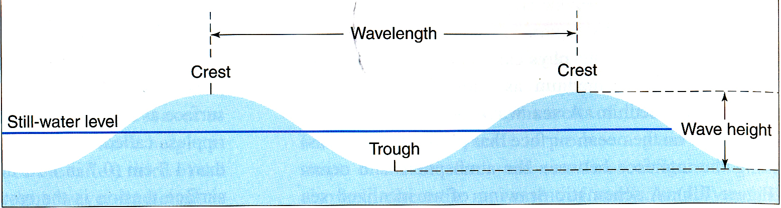
Waves have a crest which is the top of the wave, and trough, which is lowest point of the wave. The distance between two consecutive wave crests is called the wave length.
Most waves are caused by the wind blowing across the water. When the wind blows across the water it develops friction which causes small waves to form. As the wave forms, the wind has a greater surface area for the wind to blow against and the waves get larger. Three factors impact wave formations
As any of these increases the waves become taller.
The wave is actually energy moving through the water, the water itself is not actually moving forward. Things floating on the water rise and fall but do not move forward with the wave. The water in the wave moves in circles un the water.
If a wave form and the energy moves away from the area where there is wind, the rising and falling of the water as the wave passes is called “swell”.
When the height of the wave to the wavelength exceeds 1/7 the wave will “break”.
In the oceans, the water does move as a result of currents which are also caused by wind movement. Air at the equator rises other air moves in from the direction of the nearest pole to fill the “loss” of the air. In effect, north of the equator, air at the equator rises and starts to move north. Because of the Coriolis force, the air moves not just northward, but also to the right. This movement of air happens in several secitions – from the equator to about 30 degrees and again from 30 degrees to 60 degrees and then 60 degrees toward the poles.
So as this air moves Northward in the northern hemisphere, it moves the water up and to the right, causing the current in the northern hemisphere oceans to move northward among the east cost of the US and across the Atlantic towards Britain. This establishes a circulation in which the water in the Atlantic at the surface move clockwise around the Atlantic.
This current keeps the western coast of Europe warmer since the current is bringing warm area from the Caribbean to the shores there.
Ben Franklin who was postmaster general of the US noticed that mail ships (using sail in those days) got to Europe faster that they got to the US from Europe. Worse, if the US bound ships came across the North Atlantic it took longer than is they took a longer route going more to the south.
When he mentioned this to his nephew who was a whaler, the nephew said he knew the North Atlantic had a current that the whales followed (and the whalers followed) that flowed to the East in the N. Atlantic. So ships travelling TO Europe from the US made good time going with the current. However, if they followed the same route they would be travelling against the winds and current and hence might even be moved “backwards”. If the ships travelled further south in the Atlantic they would pick up the currents and winds moving westward and hence made better time.
The age of exploration led to developments in navigation. Navigation involves finding where you are on the ocean (which lacks LANDmarks). Once on has a way to identify one's location on the ocean it becomes possible to know where one is. It also allows a person to indicate on a map where they are, so there is a development in cartography (map making).
To make maps, one needs to know where one is. Certainly some of the early people who moved around the oceans were not navigating in the sense that they knew where they were headed.
The indigenous people of Australia appear to have arrived there, probably from South East Asia as early as 70,000 years ago if not earlier. What would have enabled this to happen.
Later migrations (see below) in the Pacific (Called Oceania and contains Polynesians, Melinesians and Mcronesians. Australia and New Zealand) are most likely with boats rather than rafts.

HOW OCEANIC PEOPLES NAVIGATED
Polynesians navigated by use of the stars (also something used by European navigators. But the Polynesian navigators also watched to clouds which signal an island below them, and also watched the currents.
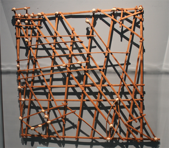
"Chart" of Stars (shells).
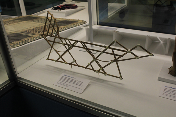
Chart shows currents and wave patters. Shells indicate islands.
How people started to go on the water is not clear, but probably they learned you could swim in the water (either by falling in accidently or getting washed away in a flood). They probably also became aware that some things floated and a person could in some instances actually ride on such a floating piece. Any floating craft which floats because it is naturally buoyant (like wood) is called a “raft” The terms, boat and ship are restricted to those vessels where the craft is made buoyant by the way the material is arranged. A boat can be made of steel and float as long as its shape makes it buoyant.
In addition to the shape of the vessel, one can talk about the methods of propulsion. Some vessels might just be carried by the currents, others use oars and still others use sail and motors.
HOW EUROPEANS NAVIGATED
Position on a map is shown by 2 coordinates – latitude and longitude. Since everywhere north of the equator there is a star called Polaris or the North Star which is almost due north at all times. At the equator, the North Star appears on the horizon. At the North Pole it appears directly overhead. So the height of the North Star above the northern horizon in degrees will give you the latitude.
If the North Star is 30 degrees about the horizon, then the observer is at latitude 30 degrees North.
So how does one find longitude? First there needs to be a starting point to determine which way is east and which way is west. This turns out to be established at the site of the Greenwich Observatory. Right near London. Everything 180 degrees west of the observatory is “west” and anything east of the observatory is east. So NY is about 70 degrees W. One hundred and eighty degrees east or west of London, the designation North and South change. So one would find as one moved further West, at 180 you would now be east!
Much of this was done by what was called ded. reckoning sometimes read “dead reckoning”. It means deduced reckoning – a way of getting one’s position by estimating the speed, duration and direction of the ships movement.
Once clocks were invented, a more exact system was developed. Since a sphere is 360 degrees and the earth (being roughly a sphere) spins on its axis once every 24 hours, then the earth moves 15 degrees an hour. (360 divided by 24).
Ships took the newly invented clocks with the on board with the clocks set at London time. When the ship was on the ocean and the sun is directly overhead it would be noon where the ship is. If the clock reads 2 pm then there is a 2 hour difference between the ship’s position and London time. Two hours would be 30 degrees so the ship would be 30 degrees WEST of London.
Ships made long voyages and sailors often had free time which they used to read, do engraving on ivory. These engravings are called "scrimshaw".
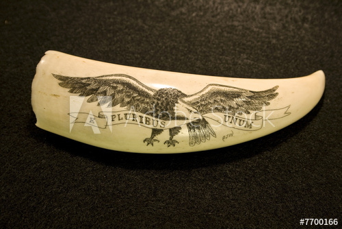
Scrimshaw.
There are also sea chanties some of which are work songs, used for work which requires cooperative action on the part of the sailors. There is also a considerable amount of decorative rope work found among sailors.
Sailors also saw many things they hadn't seen before and these were often linked to monsters like the kraken.
Some people feel that all the "monsters" are simply interpretations of things they saw and heard and misinterpreted (remember the problem of data vs. analysis), Mermaids were thought by some to be interpretations of various sea animals like seals, sea lions or other such animals. On the other hand there were many "fantastic creatures" which mix animals and humans in one animal. For example, Greek and Roman stories have centaurs who are have human and half horse; satyrs which are half goat and half human; minotaurs which are half bull and half human, It might be argued that sailors deprived of women created mermaids - one of the few 1/2 human 1/2 human female figures.
SIGNIFICANT VOYAGES
Much was unknown and many beliefs about the sea bottom. It was though it could never be measured because the idea was that sea water was compressible and as one went deeper the water became denser until it reached the consistency of lead so lead weights used to get to the sea floor would “float at that level” Buoyancy relates to density and displacement. An object floats as long as the weight of the water it displaces is greater than the object so it floats.
Some characteristics about oceans that are important – temperature, light penetration, salinity, density, nutrient concentration, oxygen concentration; depth (pressure) movement (circulation, waves, currents) wind on water, Coriolis force
Water is in fact virtually not compressible. So the water doesn’t “thicken” as it goes deeper. Capt. James Cook 1768-1771 HMS ENDEAVOR made three trips supported by The President, Council and Fellows of the Royal Society of London for Improving Natural Knowledge (founded mid 1600s and still in existence) circumnavigated the globe, made maps of S Pacific (Cartography) First first hand accounts of Australian aborigines who arrived in Australia perhaps as far back as 70,000 years ago. 1788 is the first fleet to arrive in Botany Bay
How did the indigenous people get there? Water levels lower, a bit easier to go island to island. Used rafts (not built for buoyancy use natural buoyancy) Movement onto the water not clear – swimming in ocean, floods etc. Saw floating objects – some could carry people. Unknown
Second voyage makes extensive use of chronometer for finding longitude. Tried to find Terra Australis – a mythical continent but never reached Antarctica
Third voyage was to find a NW passage, but went again to the Pacific found more islands, went back to US West Coast looking for the passage and then returned to Hawaii where he is killed by natives. The nature of the event is not well known or understood. Parallels Cortez with natives believing he is a god and then is discovered not to be.
Darwin and the Beagle 27 December 1831 - 2 October 1836
The importance of the Beagle’s voyage has to Darwin’s formulation of the wat in which coral an animal) reefs develop from barrier reefs to fringing reefs to atolls and to his theory of evolution

Darwin found that finches (a kind of bird) exhibited variation in the populations of the birds on any given island. The variation was greater between populations between islands. He felt that some of the variation made some of the birds able to survive better in specific environments. This is known as “the struggle for existence – as the number of animals increases, there is pressure on the organisms to develop more ways to survive. So some animals which are able to exploit some areas of the environment over others had a better chance to survive.
This leads to what we know think of it as a change in gene frequency – and this is evolution.
As exploration went on more and more information needed to be gathered and so vessels like the Challenger gathered information about different aspects of the ocean.