Week Three - Lecture One
The first set of definitions deal with the shore and the distance out from the shore, In the early days, people thought the ocean bottom was like a bowl. The ground sloped down from the shore, became a flat surface and then rose near the opposite ocean shore. The depth measurements taken by the Challenger showed this was not true. The bottom of the ocean was quite varied. There were valleys, chasms, mountains and as many different variations as were on the land. It is interesting to note here that once again definitions are involved in mountain heights for example. The highest mountain is generally considered to be Everest, Mona Loa in the Hawaiian Islands is not as high - if measured from sea level. But if Mona Loa is measured from its base which is on the ocean floor, it would be much higher than Everest.
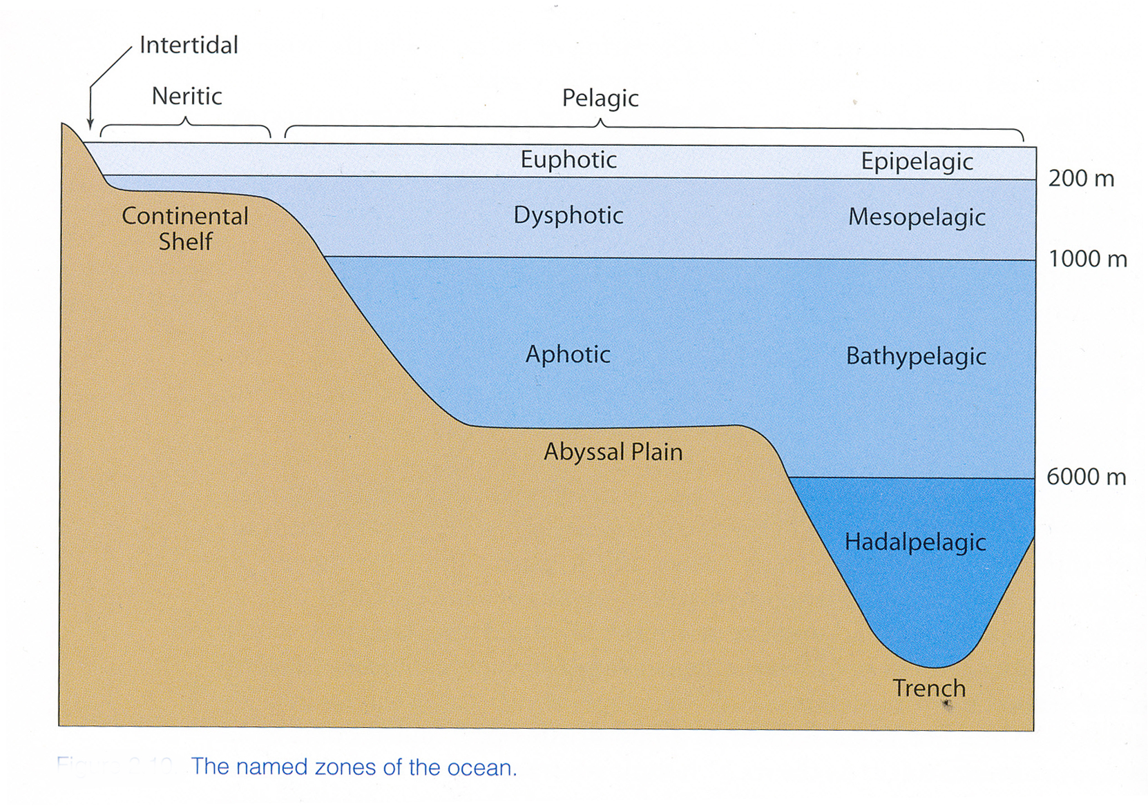
Moving out from the shore, the ocean floor slopes down along a "continental shelf" and then drops off into the ocean depths. First, one notices at the shore, there is a place where the water comes at "high tide" and where it is at "low tide". This is a part of the shore which is referred to as intertidal and is sometimes underwater and sometimes not.
The next area is called the littoral zone which is defined, not by a specific distance from the shore which is consistent, but rather, the distance from the shore where sunlight can reach the sediment. This means in some places, if the water is very clear and not turbid, the depth may be much deeper than places where there is a good deal of material in the water and the light cannot penetrate as far. Usually it is about 50 to 100 meters deep but may go as deep as 200 meters. The reason this is important has to do with the fact that autotrophs (organisms that can manufacture their own food) usually need light to perform photosynthesis. They contrast with "heterotrophs which are animals that need to consume food. The idea of primary production (the start of the food chain) is very critical for life in general
Following the Littoral zone comes the zone where the water column is over the continental shelf. This is called the neritic zone.
Everything after that is called pelagic
In addition to the above zones which are measurements from the shore, there is also a classification of the water column vertically.The uppermost level of the water is called epipelagic (one top of the ocean) or euphotic (good light). Once again the emphasis here is on how well light can penetrate the water.
Below this epipelagic level is the mesopelagic level. This is sometimes called the dysphotic (badly lit) zone. There is enough light for animals to see, but not enough for photosynthesis.
Still deeper is the Bathypelagic (sea deep) or aphotic (no light) zone.
Some scientists have also used the word hadalpelagic (Sea of Hades) zone to refer to the ocean waters in the deep trenches.
Finally, there are many ways of classifying the organisms that live in the ocean relative to where they live and how the locomote. Animals which live on the bottom are known as benthic. Those that live in the water column are known as pelagic.
Pelagic organisms are classified by their ability to move relative to the currents. Those which are moved about by the water or can only manage small movements on their own are known as plankton. Some of these are plants or phytoplankton and others are animals or zooplankton.
Those which have the ability to swim are called nekton
OCEAN MARGINS AND BOTTOM
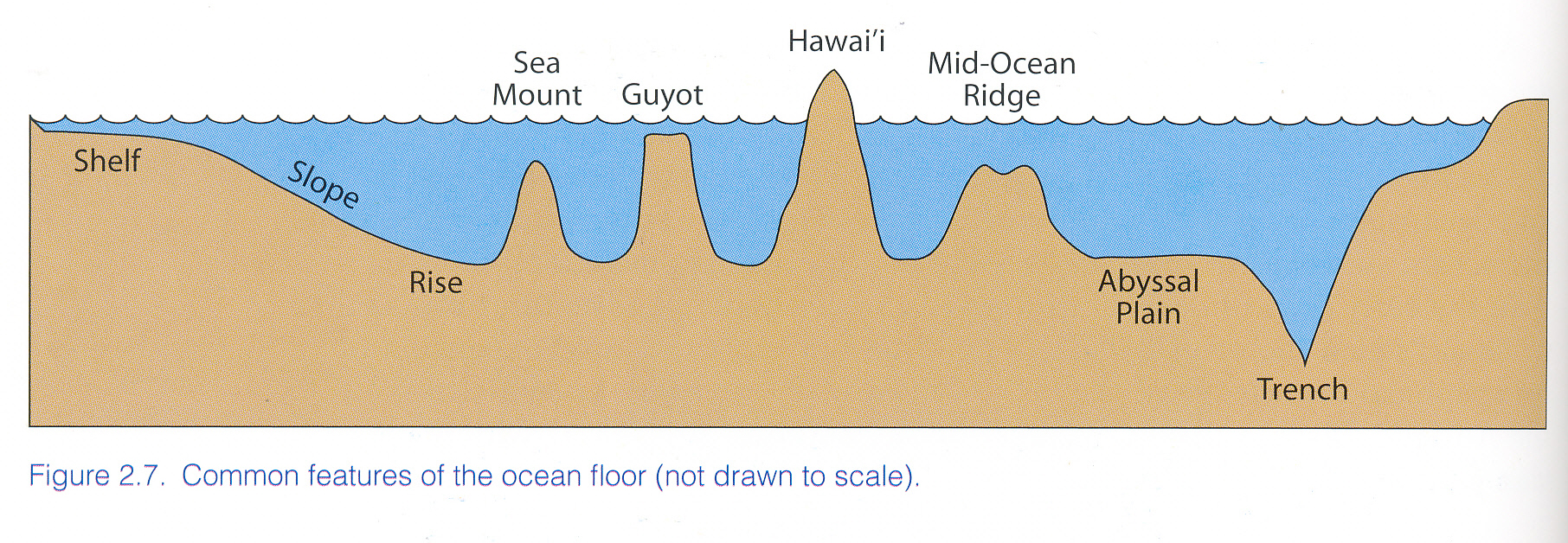
The ocean floor starts as we heard, with the intertidal zone - the part of the shore which is alternately covered and exposed by the tides. Continuing out from the shore, the continental shelf continues out and then drops off to the deep ocean basin Abyssal Plain (not abysmal) In the deep ocean basin there are many different features - broad plains, submerged volcanic mountain ranges and deep trenches.
As we cross the ocean bottom we meet SEAMONTS (not tall enough to reach the surface); GUYOTS (gheOHS) which come close to the surface – enough to have flat tops. Volcanic islands like the Hawaiian Islands. Mauna Loa 4,300 m (14,107 feet) above sea level; 10,500 m (34,448 feet) from ocean floor 2000 m (6551 feet) higher than Everest
One of the prominent features in the ocean basin are the mid-ocean ridges This is a continuous series of underwater mountain ranges that run along the floors of all the oceans, In some places, namely Iceland, the ranges appear above the water. The discovery of the ranges was of importance to the idea of plate tectonics which had been proposed by Alfred Wegener.
These mountains or ridges are places where new sea floor is being built. As the material emerges from the ocean floor it piles up and moves out. In some places (Iceland) the ridge appears above the water. The creation of new sea floor is offset by the collision of plates which can be "head on" or sliding against one another. In head on collisions, one plate generally is pushed under the other with the material being "returned" below the crust again where it will ultimately be spewed out again.
When plate collide or abrade one another, they get locked together pressure builds up. Finally there is slippage and this causes an earthquake.
Wegener noticed that the continents appears to fit together and postulated a single original land mass he called Pangaea. In addition to jigsaw puzzle like interaction of the continents, fossils found on the West Coast of Africa and the East Coast of South America. The theory was not well regarded because there was no way that Wegener could supply a force that would move the continents around. The explanation as to HOW the continents could move came about from the idea that they were floating on a somewhat liquid material.
When scientists began to discover some of the forces at work in the bottom of the Ocean, things became clearer.
THE IDEA OF THE FLOATING CONTINENTS. WHAT FORCES COULD MOVE THEM?
Floating is based on buoyancy. One has to consider the material which is floating and the material in which it is floating. An object floats when the area of the object displaces the same amount of as its weight, although the situation is more complex than that. A denser material with sink and a less dense one will float. How much of the floating object is submerged is a function of the densities of the floating object and the material in which it floats.
Here are some (average) densities
| MATERIAL | DENSITY |
| Ocean water | 1.028 g cm3 |
| Ocean crust (basalt) | 3.0g cm3 |
| Upper mantle | 3.3 g cm3 |
| Continent (granite) | 2.7 g cm3 |
So the continents and ocean crust are “floating” on the upper mantle (not unlike the way ice floats on water). Ice has a density of 0.91 and water has density of 1.0. This means that 91 % of the ice will be submerged.
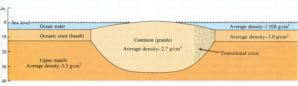
This means the continents can float.
The constant production of new land moves the floating continents around on “plates” which can and do collide. In some case the emerging material pushes plates apart. In some cases the plates collide and one subducts under the other, in others plates slide against one another
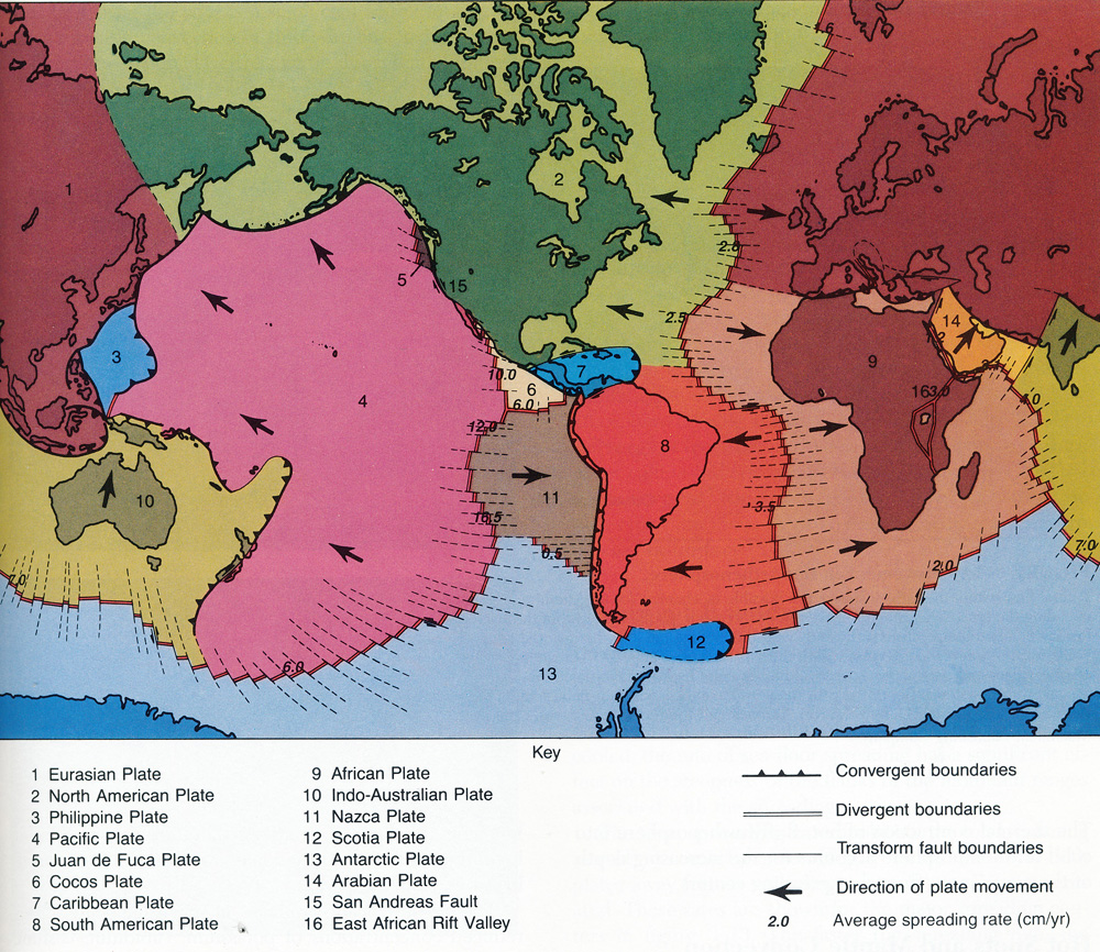
When the plates push against each other, they build up tension and the tension may give suddenly when one plate (or part thereof) slips suddenly against the other. This is the cause of many earthquakes. On occasion this causes new bodies of water to form as occurred with the Red Sea and Gulf of Aden when two plates moved apart. Not all waters are created this way. The Persian/Arabian gulf for example is produced by rising sea level.
MAP SHOWING RED SEA AND PERSIAN GULF
PERSIAN/ARABIAN Gulf formed about 15,000 years ago. It was a river valley and wet lands. Rising sea levels inundated the area. Archaeological evidence shows habitation sites which would now be underwater. This is also the case as mentioned earlier with sites indicating migrations of people across the Bering Strait and down the Pacific Coast but much further west of what is now the coast line. Rising Sea Levels as the glaciers melted have covered over these sites as well.
An undersea earthquake or other geological activity such as volcanic eruption can cause tsunamis which can cause tremendous damage and loss of life. A bit about the Richter Scale.
Earthquake intensity is measured with the Richter scale. The Richter Scale like the Fujita scale for tornados (see below) is a scale which indicates the severity of the earthquake, The numbers are logarithmic so they increase by increments of 10. So a "2" on the Richter scale is 10 times stronger than a "1" while a "3" is 100 time stronger than a "1"
The lowest level quakes, "1"s go unfelt by most people, while a 10 is catastrophic.
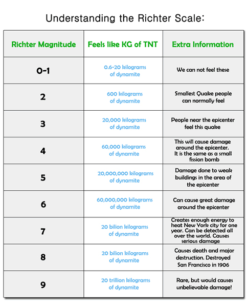
RICHTER SCALE (Earthquakes)
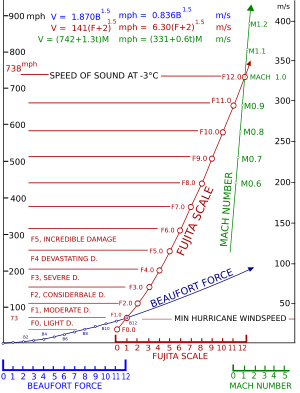
FUJITA SCALE (Tornadoes)
And there is a separate classification system for hurricanes known as the Saffir Simpson Clssification System
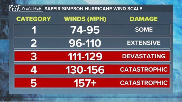
Saffir-Simpson Hurricane Wind Scale
Winds in general are measured by the Beaufort Scale which goes from "calm" to "hurricane" winds
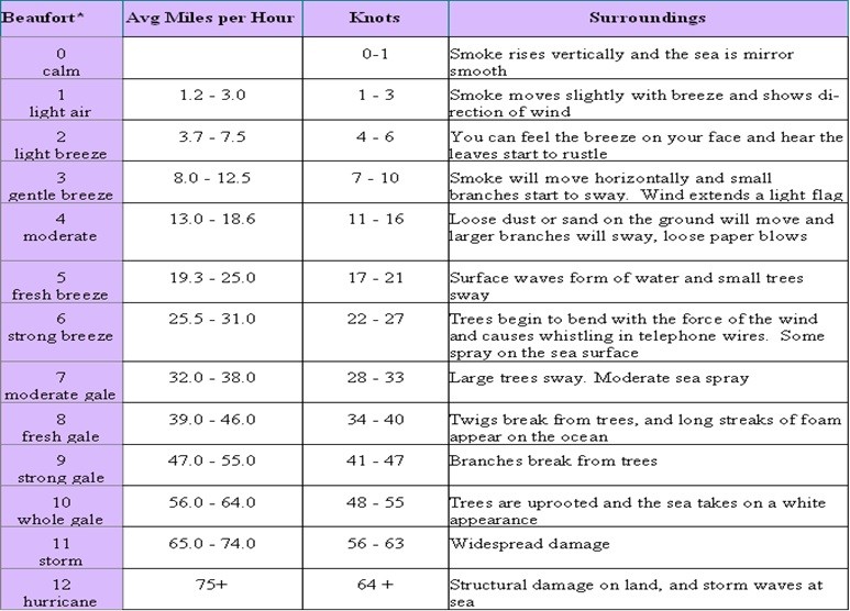
BEAUFORT WIND SCALE
Some serious Tsunamis:
Santorini (Thera) An enormous volcanic eruption which produced a tsunami Somewhere around 1628 BCE Evidence from Greenland, California tree rings Climate affected – crop failure in Chine, part of Egypt impacted, (information appears on the stele of Ahmose). Some felt that this ended Minoan Civilization but archaeological evidence finds Minoan culture after the eruption. It is possible that the society was so damaged that it became perhaps too weak to defend against a very militant Mycene. There is some speculation that this eruption is the bases of Plato's Atlantis myth.
Lisbon 1755 Nov, 1st at 9:40 am. (All Saints Day) Earthquake followed by tidal wave. People reported seeing the tide go out far enough to expose some ship wrecks. Churches where many had fled destroyed for protection. Many candles lit which helped ignite fires all over. Many other cities hit. About 200,000 people in Lisbon. About 30,000 to 40,000 people killed about 10,000 more in Morocco. This event triggered the beginning of the science of seismology in Germany, Led to many theological problems – why did this happen on a High holy day (All Saints Day) destruction of Churches and people looking for refuge in them being killed.
Krakatoaor Krakatau August 27 1883. The eruption of Krakatoa was preceded by minor rumblings and ventings. Then on Aug 27 there was the first major eruption which generated a cloud plume 20 miles high and triggered several tsunami. The following day there were 4 major eruptions in a 4 and a 1/2 hour period. The last is credited with being the largest sound recorded on Earth. It was heard in Australia and an island called Rodrigues 3,000 miles away. Villages on Java and Sumatra were destroyed. an estimated 35,000 people died. Chunks of coral weighing 600 tons were found on the shore. Tsunami went nearly around the world with places thousands of miles away having large waves.
Sunlight in the immediate area was blocked for several days and within weeks people all over the world saw the sun a strange color. This was caused by the dust in the stratosphere. Global temperatures fell for several years as a result of the reduced sunlight from the ash. Krakatoa basically blew itself apart but a new volcano called Anam Krakatoa is forming at the rater of about 5 inches a week.
Indonesian Earthquake and Tsunami or Indian Ocean Earthquake and Tsuname Dec, 26, 2004 (9.1 - 9.3 on Richter Scale) The death toll across 14 countries was about 230,000 people. It was the third largest earthquake ever recorded and lasted 8.3 to 10 minutes. Indonesia was the hardest hit, with Sri Lanka, India and Thailand also suffering major losses. In 1960 the Great Chilean Earthquake registered 9.6 and the 1964 Good Friday Prince William Sound Earthquake which registered at 9.2 are the only greater earthquakes recorded.
There was great ecological impact both in the ocean itself and along the coastlines. Scientifically there has been the development of a much greater warning system in the Indian Ocean.
Tohoku earthquake March 11, 2011 a 9.0 earthquake off the coast of Tohoku (N.E. Japan) resulted in a tsunami the struck Fukushima, Iwate Prefecture. The number of confirmed deaths is 15,891 as of April 10, 2015, according to Japan's National Police Agency. Most people died by drowning. More than 2,500 people are still reported missing.
It was estimated that in one part of Iwate Prefecture, the tsunami may have been 127 to 133 feet high.
Sendai (the major city in Fukushima) has an airport near enough to the water that wave washed cars and planes away at the airport.
The Japanese, as the only people against whom nuclear weapons of mass destruction have been used (in Hiroshima and Nagasaki near the end of WWII) have a great deal of concern about nuclear matters and there is a split in the population about nuclear reactors. The Fukushima Daiichi Nuclear Power Plant suffered a meltdown and a good deal of radioactive material was washed into the ocean. In Fukushima, Tochigi, Gunma, Tokyo, Chiba, Saitama, and Niigata prefectures, there were reports that radioactive material was found in tap water. The fishing of some species of fish was also banned because they were found to have radioactive material in them/
Nuclear meltdown:
The tsunami caused a cooling system failure at the Fukushima Daiichi Nuclear Power Plant, which resulted in a level-7 nuclear meltdown and release of radioactive materials. The electrical power and backup generators were overwhelmed by the tsunami, and the plant lost its cooling capabilities. In July 2013, TEPCO, the Tokyo Electric Power Company, admitted that about 300 tons of radioactive water continues to leak from the plant every day into the Pacific Ocean.
Hurricanes are winds around an extreme low pressure area. The low pressure is caused by air being warmed and rising. Winds then move into the low pressure area moving to the right (counterclockwise) in the Northern hemisphere and the reverse in the Southern. This is the result of the Coriolis force or effect. Winds in the northern hemisphere veer to the right, in the southern hemisphere to the left.
This is caused the the fact that a sphere which is rotating moves faster near the "equator" than at the poles. At one foot from the pole, one can walk 360 degrees in a few steps, but at the equator the person would have to walk 24,000 miles or so. Since the world rotates on its axis once in approximately 24 hours, the part near the equator must cover about 1000 miles an hour, whereas at the poles it travels only a few feet in 24 hours.
If you imagine a line of skaters or dancers which is revolving around the center of the line, you realize the people toward then center move much slower than those at the outside. The people at the ends of the line mustt travel very fast while the people in the center go rather slowly. If the line rotates counter clockwise (as the Earth does if you were to look down at the North Pole from space) the line of dancers/skaters would curve to the right as they try to catch up.
If yiou looked at the Earth from outer space from over the South Pole, it would apear to rotate clockwise. A line of dancers/skaters rotating clockwise would bend to the left.
So hurricanes in the North rotate counterclockwise, since the air moving into the low pressure senter begins to veer to the right.
Hurricanes season is considered to be from June 1 to Nov. 30. September is the generally to most active month. This because these are the times when the ocean temperature is higher. The hurricanes in the Atlantic begin as low pressure senters coming off the coast of Africa and then they move out over the ocean where they gain energy from the warm water. The air heats and rises causing the low pressure to drop even lower. Because of the pressure gradient (the difference in pressure horizontally in the air) the air moves into the lower pressure areas (air moves from higher to lower pressure). As it move in, the Coriolis effect causes the air moving in moves to the right, and the low pressure center has a counter clockwise turn. The water produces moisture as well and the low pressure area may intensify and when winds reach 74 miles an hour, the event is labeled a hurricane.
The center of the rotation is called "the eye" and the area immediately around it is the eye wall. On land, the eye is rather calm, but on the ocean it is an area of violent wave activity since the waves are formed by wind direction and the winds are blowing from all directions around it.
For ships at sea, being in the eye of the hurricane is the worst place to be. Waves are large and come from all directions.
On September30th of 2015, the 791 foot long freighter, El FAro, at 791 feet long, left Jacksonville Florida en route to Puerto Rico with 391 shipping containers. AT the time, a tropical storm Joaquin in the Atlantic was building and expected to become a hurricane by the next day. The ships course would have taken it into the path of the hurricane which was rapidly intensifying. The ship took on water, began listing and then lost propulsion. THe Emergency Position Indicating Beacon (EPRIRB) sent messages as to where the ships was. Two databases indicted slightly different positions, and one put the vessel in the eye wall just before all contact was lost.
Hurricane Hunters and the US Cosat Guard aircraft began a search for El Faro and later they wre joined by a Coast Guard vessel and a Coast Guard helicopter, but no trace of the ship was found. On October 3rd while flying in hrricane force winds, a life ring was recovered. Debris and some bodies and a damaged life boat were found. On Oct 7th the search was discontinued. On Oct 31 soundings located a vessel at 15,000 feet deep which turned out ot be the ship.
There were 33 people on the ship 28 Americans and 5 Poles. All hands were lost.
When hurricanes come on shore, they often produce large storm surges in which the water level rises dramatically. If the coast is steep, the water may not move far inland, but if the shore is gently sloping the water may move quite a distance inland. Current thoughts are that under the "right" circumstances, storm surge could raise the water level in Brooklyn so that there would be water as far inland as Ave, I.
Since the hurricane is rotating in a counterclockwise direction being on the NE corner is the the worst part of the storm. At that point the water is pushing higher into the land. On the NW side, the winds are pushing away from the land. In addition to the shape of the shore line, and which part of the storm is arriving (NE or NW quadrant), there are other factors to consider. Among these is the forward speed of the storm, the speed of the wind, the nature of the land where the hurricane comes ashore (rocky, sandy etc.) and the amount of rain. Clearly a slow moving storm stays longer and hence dumps more rain. Attempts to block incoming seas imitate some natural phenomena like sand bars by building breakwaters - a kind of wall in the water. Some hurricanes have overtopped the walls, or destroyed the walls. Such walls however have an effect on beach erosion. Some of the land has plant life which has long roots and help stabilize the ground and keep it fom washing away. In some cases the building of houses on the shore line leads to the loss of such plants and the destructioni of sand dunes which may also help control water movement.
On Sept. 8th 1900 Galvestonwas strck by a hurricane struck causing incredible damage.
The city of Galveston was a hub of businesses with a population of about 36,000 people. It has a natural harbor which helped its growth. It was built basically on a sandbar, with highest point being some 8.7 feet above sea level. Some concernedd citizens had suggested the builing of a seawall (a wall on the beach basically) to protectthe city but the majority of the population thought it unnecessary and so one was not built. There had been a good deal of building going on in the city which led to the destruction of sand dunes to fill in low areas of the city and in this way what protection there was was destroyed. There had been storms before which the city had survived which led to some complacency. Isaac Cline of the weather bureau thought it would not be possible for the city to be struck by a hurricane. The weather service at that time had little information about weather at sea and relied on reports from ships.
Cuba forecasters were predicting the storm that they were experiencing, would head toward San Antonio, but the US weather bureau argued that the storm would curve and strike Florida. Isaac Cline's role and that of his meteorologist brother Joseph have been a bone of contention with some people crediting them with giving a hurricane warning before the central office approved it, while others claim their role was negative in that they resisted the idea of building the sea wall.
When the storm surge hit, the waters rose over 15 feet - almost twoce the depth of the highest piece of land. The entire isalnd was submerged and over 3,600 hundred buildings were destroyed. Estimates of the death toll rose to somewhere between 6,000 and 12,000 people (official reports claim 8,000) making it the greatest natural disaster to strike the U.S.
Disposing of the dead was a major problem and bodies were weighted and placed on barges and dumped at sea. The cirrents brought many of the bodies back to shore and the survivors were reduced to building funeral pyres and burning the bodies.This went on day and night for weeks after the storm.
It is reported that there were more people killed in this storm than in all the other cyclones to have struck the US.
TIDES
Water is moved by tides. Tides are the raising and lowering of the waters generally twice a day,
The tide is caused by several things, most importantly the relationship between the sun and moon and earth. In its simplest form, we need to remember the earth circles around the sun and the sun around the earth. Both of these celestial bodies exert a gravitational pull on the earth. The sun while bigger, is much further away from the earth and has a lesser impact on the tides.
The moon circles the earth in about 28 days At one point the sun and moon will line up on the same side of the earth,
| SUN-------------------------- | MOON------ | EARTH |
At this point the pull is the strongest on the earth because the gravitational pull of the sun and moon are on the same side.
About a week later, the Sun and Moon form a right angle with the earth
| SUN-------------------------- | EARTH | MOON |
A week later, the moon is on the opposite side of the earth from the sun
| SUN-------------------------- | EARTH------ | MOON |
And the following week, the moon is at right angles again with the sun and earth but on the other side of the earth.
| MOON | |
| SUN-------------------------- | EARTH |
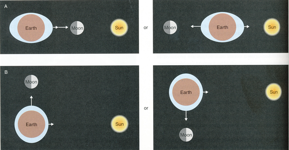
DIAGRAM SHOWING THE POSITION OF THE EARTH, MOON and SUN RELATIVE TO THE TIDES.
Highest tides are spring tides - because they "spring up" Neap tides are the lowest in the month. Remember:
On a daily bases there are usually 2 high tides and 2 low tide.
On a monthly bases there are 2 spring tides (highest high tides of the month) and 2 neap tides (lowest low tides of the month.
Since one of the laws of physics is that an object in motion will stay in motion and will not change direction unless another force is place on it. As the earth moves around the sun, the gravitational pull of the sun is less on the side of the earth away from the sun. The ocean in this case bulges because it is moving in a straight line, but is pulled along with the Earth, Hence there are always 2 bulges of ocean on the earth. One is on the side of the sun, the other on the opposite side, As the world rotates, different parts of the earth come under the bulges and experience high. So each day there will be a high and low tide.
During the month hoiwever, some tides are higher than others. The higher of the high tides is called a "spring" tide because the water "springs" up. These occur when the sun moon and earth for a straight line.
When the moon is at a right angle with the sun and earth, the tides are somewhat lower. THese are called leap" tides.
So the water moves for many reasons:
Waves
Tides
The tides and waves and winds and currents do a great deal to cause motion in the water. This is crucial since it aerates the water (mixes the water and air, and hence puts oxygen into the water so that living organisms have oxygen for repiration. It also causes nutrients which are often near the bottom to churn up as well. This is more common at the places where the ocean meets the land and is shallower than happens in the open ocean. Two more movements occur in the ocean - waves and currents. Both of these are crucial since the move materials in the ocean around.